The word a mine reaches for most often is "real time." It sounds like the safe answer. In practice it is where a lot of money gets spent on the wrong thing.
Ask a mine what it wants from a missing person locator system and "real time" is the word that comes back, because the fast, live view it implies quietly trades away the one property that actually saves a life underground: a battery that is still working hours into an emergency. The regulation is more subtle than the sales pitch. Once you read what MHSA Regulation 16.7 actually asks for, the design problem changes shape, and so does the question you should be putting to your suppliers and vendors.
What 16.7 actually says about time and battery
Regulation 16.7 requires an intrinsically safe device that can establish a person's last known location if they go missing, a system that logs data, and battery life that is set by the mine's risk assessment so that a person can be located during and after a working shift. Read those requirements again and notice what is not there: no update rate, no blink interval, and no requirement for continuous live tracking. The regulation asks for a dependable last known location and the endurance to still deliver it when it counts. That single observation reframes the whole design.
Conflicting, unsigned versions of Regulation 16.7 circulate widely. For reference, Ideas2Impact hosts the signed-off copy (Government Gazette No. 52388, Government Notice 6052, 28 March 2025). The Mine Health and Safety Council publishes the same signed version online: view the full Chapter 16 regulations.
"Real time" is the wrong question
A live dot moving across a screen is reassuring, but it is not what the regulation asks for and it is not what a rescue actually needs. What a rescue needs is a location that is fresh enough and precise enough to guide a search, and that is still available deep into an incident. A position that updated ten seconds ago is of no use if the tag is flat by the time the search begins.
So the useful question is not "how real time is it?" It is "how stale can a last known location be and still be good enough, and will the device last long enough to give me that location when I need it?" Everything else follows from that.
The trade-off, explained simply
Update rate and battery life pull against each other. The more often a tag transmits its position, the fresher and more granular the location, and the faster the battery drains. Slow the tag down and the battery lasts far longer, but the last known location is older and coarser. Every design sits somewhere on that curve; there is no setting that is both maximally fresh and maximally enduring.
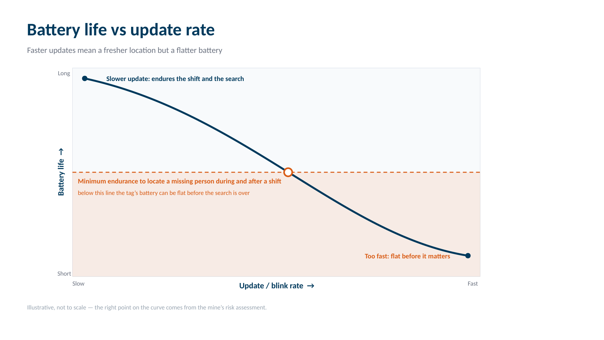
The trap is optimising for the demo rather than the emergency. A tag configured to look impressive in a control room, updating every few seconds, can be exactly the tag that dies first in a real, prolonged incident.
Coverage and the technology you choose
There is a second lever that people forget: a fast update rate is largely wasted if the infrastructure reading those updates is sparse, and a modest update rate can be more than enough where coverage is dense. Where the last known location comes from is as much about the network as about the tag. And that puts the choice of positioning technology at the centre of the conversation.
Positioning technologies sit on a spectrum. At one end, wide coverage from few nodes at low power, with location at zone granularity. At the other, pinpoint accuracy from a dense, cabled grid at higher power and cost. The technologies most often discussed for mining and industrial sites spread right across that spectrum.
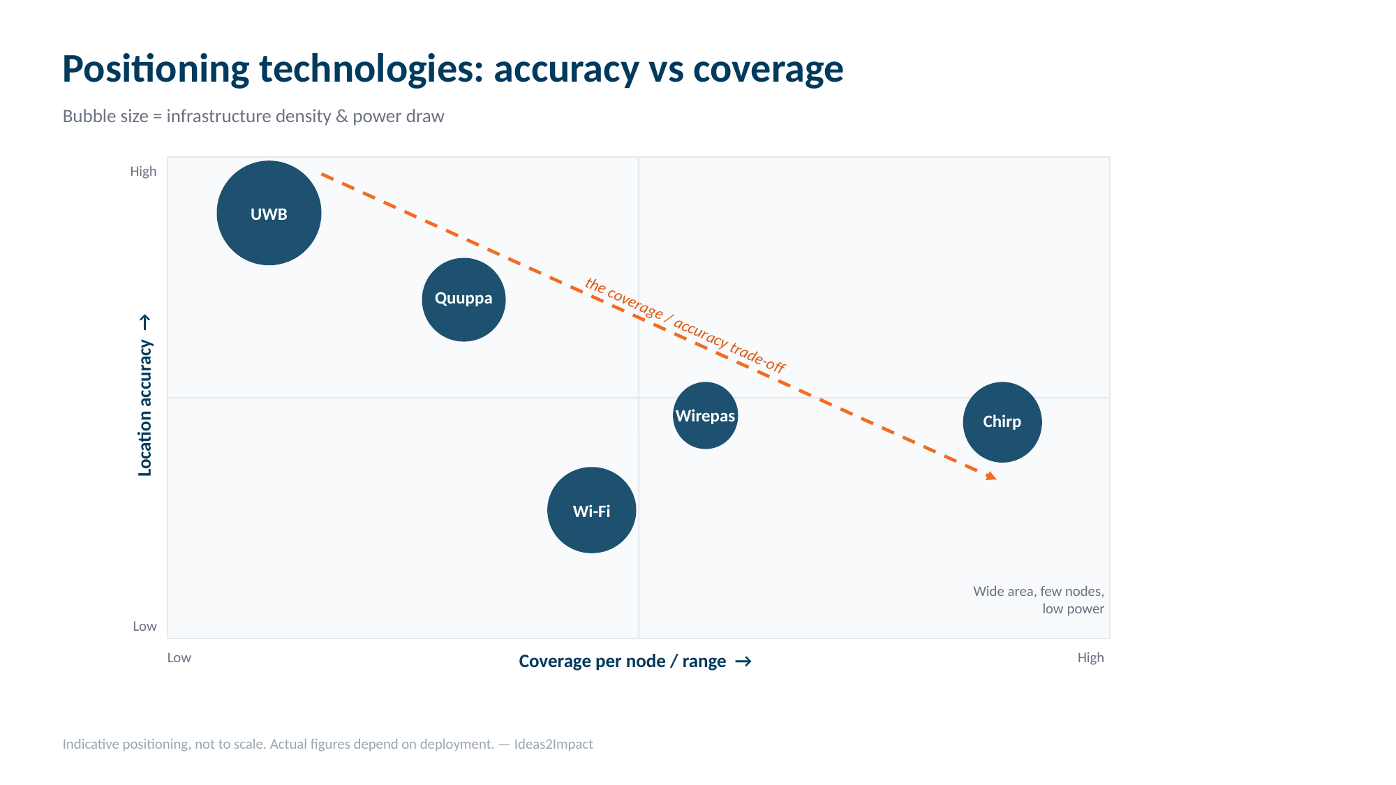
In relative terms:
- Wirepas mesh extends coverage node to node, so a few low power devices blanket an area, favouring battery life, at a location accuracy of roughly 2 to 5 m.
- Chirp, the Nanotron chirp spread spectrum approach, reaches even longer range per anchor than a mesh hop and holds up well in multipath, which suits tunnels and linear workings, at a similar accuracy of roughly 2 to 5 m.
- Quuppa uses Bluetooth angle of arrival for high accuracy, but wants a denser grid of locators and cabling, so infrastructure and power climb.
- UWB gives the highest accuracy of the group, but the shortest range per anchor, so it needs the densest, most costly infrastructure and draws the most tag power.
- Wi-Fi positioning reuses a site's existing wireless network, so it can add location coverage with little new infrastructure wherever a wireless LAN already reaches, but the position is coarse and a Wi-Fi tag draws more power than a low energy beacon, which weighs directly on battery life.
None of these is "best." Each is the right answer to a different question. A technology that blankets a large area on a long battery serves the missing person locator job in a way that a high precision, short range technology, deployed across a whole mine, would struggle to match on cost and endurance, while the high precision technologies earn their place in the specific zones that genuinely need them. The point of the matrix is not to pick a winner. It is to show that the moment you fix an accuracy expectation, you have also fixed your infrastructure density, your power budget and, through that, your battery life. These are not four separate decisions. They are one.
There is a coverage point that matters underground more than almost any other. Fixed and wired technologies, Wi-Fi included, only track up to the last installed infrastructure. But a mine is never static: the workings advance constantly, and the installation of fixed infrastructure tends to lag behind the development of new areas. Meanwhile most people are working at the face, in the newest ground, which is exactly where real time location matters most and exactly where the cabling has usually not yet reached. This is where an easily extended mesh such as Wirepas, or a long range wireless technology such as Chirp that can reach remote areas without new cabling, has a decisive edge over infrastructure that stops where the last cable was pulled.
For indicative accuracy, range, battery life and relative cost across these technologies, see the comparison table on our Technology page.
The requirement that bites: after-shift endurance
Of everything in 16.7, the clause that quietly defeats the most systems is the one about locating a person during and after a shift. An incident does not politely occur at the start of a shift with a freshly charged tag. The device has to have enough left to be found through the hours a rescue can take. A specification that only proves battery life "over a shift" under ideal conditions, at a gentle update rate, can still fail the moment a real search runs long. Endurance under the actual configured update rate, late in a shift, is the number that matters, and it is rarely the number on the box.
There is a certification dimension to endurance too. In fiery ground the device's protection level decides whether it may even stay on during a gas event. Equipment marked Ex ia I Ma may remain energised through an outbreak of gas, whereas the lower Ex ib I Mb level is expected to be switched off when gas appears. A locator that is required to switch off, or whose battery is flat, fails the same during and after test for opposite reasons. The companion article on certification covers this in full.
How to work out the right update rate
Rather than starting from a tag's headline specification, the sound approach runs the other way. Start from the search scenario: over the area and layout in question, how old can a last known location be and still send a rescue team to the right place? Factor in the coverage you can realistically achieve and the risk of each zone. Only then set the update rate and the battery target that satisfy that scenario, and choose the technology that delivers the needed coverage and accuracy at a power budget the endurance requirement can afford. Done in that order, "real time" stops being a slogan and becomes a number you can defend to an inspector and, more importantly, rely on in an emergency.
Do not forget the log
The regulation's data logging requirement is easy to treat as a checkbox, but it is a rescue tool in its own right. A single last ping tells you where a person was once. A logged path tells you where they were going, how fast, and where to concentrate a search. A system that shows a live view but stores little history satisfies neither the spirit of the regulation nor the needs of the people doing the finding. As we put it in the companion article on certification, a tag is not a system.
What good looks like
A short way to sanity check a proposed missing person locator system:
- The update rate is justified by the risk assessment and the search scenario, not by a headline figure.
- Battery life covers a person being located during and after a shift, tested at the configured update rate.
- The positioning technology and coverage design match the accuracy the mine actually needs, zone by zone, at an affordable power budget.
- Location history is logged, not just shown live.
If a proposal cannot speak to all four, it has not been thought through.
How Ideas2Impact helps
The reason we have set this out as trade-offs rather than a single recommendation is that there is no single recommendation. The right update rate, battery target, coverage design and technology mix depend on the mine, its layout, its zones and its risk assessment. What Ideas2Impact brings is the experience to work that problem as one decision rather than four, and the independence to match the technology to the mine rather than the mine to a product.
Weighing up a missing person locator system?
We will help you pressure test where a proposed system sits on these trade-offs, and design coverage that stands up to both an inspection and a real incident.
Start a conversationThe wording of Regulation 16.7 in this article follows the signed Government Gazette No. 52388 (28 March 2025). This is general information, not legal or compliance advice; confirm your specific obligations with your appointed advisors.